http://www.buxtoniowa.com • Consol, Haydock & Buxton Iowa, USA • 1871 - 2014
Coopertown Iowa a Coal Mining Camp
Suburb of Buxton, Iowa
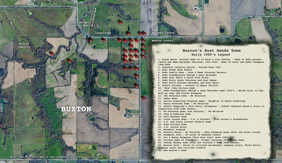
The coal mining camp of Coopertown, Iowa is often referred to as a suburb for the Buxton, Iowa coal mining camp. It is doubtful that at the turn of the 20th century the word “suburb” was even in the English language. Nonetheless, history identifies Coopertown as a suburb of Buxton. The boundaries between Coopertown and Buxton were easily identifiable since the Mahaska/Monroe County Line Road (340th Street) divided the two coal mining camps. Coopertown was north of Buxton in Mahaska County, while all of Buxton proper was south of the county line road in Monroe County.
Besides being in different counties, the difference was to a large extent due to the desire of businesses and residences to escape the regulations and restrictions that the coal company had placed on those living or doing business in Buxton proper. Since the company owned virtually all of the one square mile of land and houses in Buxton proper, the company ruled Buxton autocratically. If you didn't like it or created any problems you would have been asked to leave Buxton proper. The population in Buxton proper in the early 1900’s was in the thousands, some say over 5,000 miners and their families.
Since neither Coopertown nor Buxton were incorporated, it is difficult to know all of the differences between the two camps. However, we do know that the most prominent difference was in the matter of the selling of liquor. The sale of liquor was only permitted in drug stores in Buxton. For that reason, I don’t believe there was ever a saloon or a bar in Buxton proper (the area owned by the coal company). Instead, a series of rings developed surrounding Buxton proper. Besides Coopertown, other suburbs included Gainestown and Hayes Town, just to the west of Coopertown and also in Mahaska County and Tait’s Corners, across from the southeast corner of Buxton in Monroe County.
Much of the border land around Buxton, other than the for the suburbs, was agriculture. Hobe Armstrong had a large acreage to the east of Buxton. The Blomgren farm was north and J.E. Larson had a store and property to the east of Buxton.
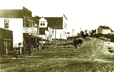
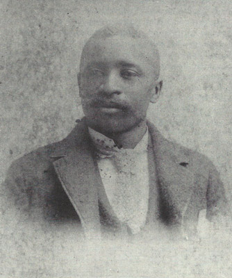
Coopertown was named after B.F. Cooper who owned a pharmacy in Coopertown. My grandfather, David Peterson, owned a grocery store with Albert Hagglund in the same building with the Cooper Pharmacy. The Cooper Pharmacy building was the second building east of the railroad tracks. B.F. Cooper was the first black pharmacist in Iowa. Cooper died at a young age in 1915. He was the founder of the Buxton Wonders baseball team and it’s first manager. As one would expect with Cooper’s interest in baseball, there was a baseball field in Coopertown. Although most of the Buxton Wonders games were played at the Amphitheater baseball park in southeast Buxton at Tait’s corners.
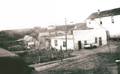
Other businesses on Coopertown’s main street included the Granberry Tailor shop in the same building with the Jim Robert’s cigar store. My Dad, Ray Peterson, as a youngster enjoyed watching cigars being rolled in the cigar store. The John Wright’s club room was located on the second floor of the Cooper Pharmacy/ Peterson/Hagglund store building. The Rising Sun restaurant that was operated by Mrs. Anna Lobbins was the first building east of the railroad train tracks that ran through Coopertown. My Dad remembered injuring his leg when he was once crossing the railroad tracks. The restaurant was later replaced with a hotel that Rueben Gaines built. The suburb of Gainesville to the west of Coopertown was owned by Gaines. The restaurant building was not much of a building, but the food and coffee were considered to be excellent. B.F. Cooper also owned the two story building on the east end of main street. It had a roller skating rink and dance hall on the first floor.
It is interesting that all the dances and roller skating events were segregated between blacks and whites. Blacks and whites in the coal mining camps were very integrated in all aspects of their lives including housing, education and employment. The one exception was in social activities, such as dancing and roller skating. The fact blacks and whites were so integrated in the coal mining camps in the early 1900’s was a credit to both the blacks and the whites and was quite unusual for that time in our countries history.
One of the great unsolved mysteries regarding Rueben Gaines and Gainestown is if the pipe that currently is sticking up out of the ground under the Bluff Creek Bridge is to the underground “Still” Mr. Gaines was reputed to have built. In a recent visit with Scotty Schippers, who lives up the hill from the bridge, he seemed intent on finding out by digging up the pipe. Should Scotty decide to dig up the pipe, it will be interesting what he discovers.
My Grandfather delivered groceries by horse and buggy from his store in Coopertown. Since transportation was not readily available to the miner households, my Grandfather offered home delivery. He took orders by horse and buggy one day and delivered the next. I believe my Grandfather’s first gas driven vehicle was a 1915 Ford truck.
A fire in 1916 destroyed most of the businesses in Coopertown, including the B.F. Cooper building where my Grandfather and Albert Hagglund’s store was located. At the time of the fire in 1916, the Consolidation Coal Company was moving its coal mining operation from Buxton southwest 25 miles to the Consol coal fields. Grandpa followed the coal company by opening a store in the Consol coal mining camp. He didn't reopen a store in Coopertown. I doubt any of the stores in Coopertown were ever rebuilt or reopened after the fire. The population of Coopertown was not more than 100 residents, even in its heyday. It was ten acres at the most in land size.
Coopertown did have the notoriety of having more than its share of drinking and gambling. Obviously with the restrictions in Buxton proper for saloons and the selling of liquor and Coopertown being ideally located just across the road from Buxton, Coopertown’s notoriety for booze and gambling was very likely true. East Swede Town was just up the road from Coopertown. It wasn't uncommon for Swedish miners, including some from my family, to frequent Coopertown. That said, Coopertown wasn't nearly as rough an area for drinking and gambling as was Tait’s Corners that was one mile to the south from Coopertown. Shootings at Tait’s Corners were a common occurrence. A pistol stolen from a member of my Grandfather’s family was used in a murder at Tait’s Corner’s. The pistol was returned to our family by the constable, Tom Roman, and is still in the family to this day.
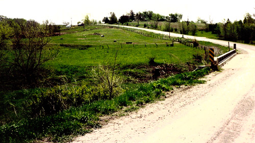
If you drive west from the K Road (650th avenue) along the county line road (340th Street) and just before you reach the Bluff Creek bridge, the old railroad bed that ran through Coopertown is easily identifiable. The railroad beds were made from waste created during the coal mining process. After the railroad tracks were pulled in the 1930s the track beds made for very poor farm land for growing crops of any kind. Therefore, they were used for tractor paths in the pastures and fields that replaced the coal mining camps such as Coopertown. If you stop at the railroad bed and look back up the hill to what was once Coopertown’s main street (toward where the Scotty Schipper’s family home is now located), you will be engulfed in a time a century ago when the area bustled with activity. The large locomotives pulling train cars full of coal through Coopertown will conjure up a mystical feeling that will take you back in time over 100 years to the “Coal Dust” era.
The article was written by Gordon R. Peterson who has spent his life exploring his families history in the coal mining camps of Monroe County, Iowa. For the most part, the information Peterson learned was from family members with an occasional reference to material published by John Jacobs of Rose Hill, Iowa, a true historian of Iowa coal mining. Peterson lives in the Minneapolis, Minnesota area.
Looking Back, Albia Newspaper, June 17, 1915
A booze raid at “Mollie’s Place” in Coopertown by Sheriff Robinson and Deputy Tedford landed Frank Douglas, colored, in the county jail and a large quantity of the “juice of joy” in the county strong box. Officers dumped 26 gallons of home brew onto the ground and brought 26-quart bottles and a quantity of whiskey back to Albia. At the time of the raid the joint was packed with patrons.
