http://www.buxtoniowa.com • Consol, Haydock & Buxton Iowa, USA • 1871 - 2014
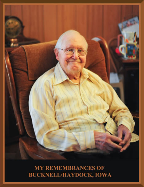
Francis Madison Butcher
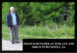
Picture taken May 11, 2009 At Sawyerville, Illinois
FOREWORD
Over the years, the routing of roads has changed. In particular, in the 20s, the routing of 160th street at the east side of Bucknell ran due east/west while today it angles to the north. Very little is left to identify the original streets. My dad has made an attempt to indicate, at least approximately, where the original buildings were located. His recall is phenomenal. He not only remembers details of all of the locations but can recount details of the people, their families and even their dogs and cats. We have made every attempt to be reasonably accurate but no one has a perfect memory so there may be errors.
Virtually all traces of what was once Bucknell, Haydock and Consol are gone.. When the mine industry collapsed in the region around Bucknell and people moved away, my dad’s family moved to Eagerville, Illinois. It was common for people in the mining communities to refer to their town as much by the mine number as the town name. Eagerville was #1 and the region that was the mine “patch” has no buildings remaining. My dad’s home in Eagerville is gone as well as the houses where he lived in Iowa. He now resides in Sawyerville, Illinois (mine #2). There are no traces of the mines left.
Each mine had an associated waste pile resulting from the separation of slate and rock from the coal. The waste was often simply dumped in a big pile sometimes with a railroad track rising to the top where the growing mountain of waste was pushed over the edge. More track was continually added and the waste mountains (the “gob” or “slag/slack” pile) rose to above the mine “tipple” … as much as 100 feet. There are no traces of the waste piles left. Most were cleaned up with the federal “Super-Site” cleanup program. During the heyday of the mines, rain runoff from the waste piles contained large quantities of sulphur which caused creeks to run orange. Now, nothing is left.
Please forgive any grammar or spelling errors. We have not tried to create a thoroughly edited history book. We have made an attempt to inform and amuse. We hope we have been successful.
Daryl T. Butcher (son) who served as word processor jockey.
June, 2009
MY REMEMBRANCES OF
BUCKNELL/HAYDOCK, IOWA
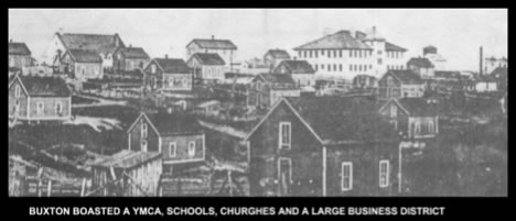
BUXTON
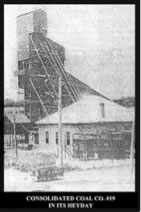
I was born in Buxton, Monroe County, Iowa. My father’s name was R. W. BUTCHER and my mother’s name was Ethel May (CHAMBERS) BUTCHER. I don’t remember anything about Buxton as I was too young when we moved away from there. My father became a Surveyor in his early days in Buxton and worked for the Consolidation Coal Company in Iowa and the Superior coal Company in Illinois until he retired in 1952. There are some pictures following that gives you some idea of what Buxton looked like and views of the only industry that was there.

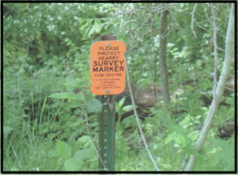
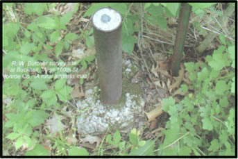
I told you my father was a surveyor. In the case of a proposed coal mine a great amount of survey work must be done. First the owners of the land and the Coal Operators must agree to the boundaries on the land under which Coal Operators want to mine out coal. Surveys must be run then and boundaries must be set in a contract between the land owners and Coal Operators, and recorded before a shovel of dirt is removed from the area of the proposed mine shaft.. Then when the mine shaft is finished and coal is removed surveys have to be run daily to stay within the boundaries set in the contracts. So you see this is a sort of survey done twice, at ground level and at the coal vein. My father did this type of work for many years until he retired in 1952. One of my father’s survey markers can be found on 160th street in Bucknell. This site was made prior to 1920 and may be as early as 1916 or earlier. As you go into town from the east you encounter a big hill. Over the top of the hill about 200 feet on the left side of the road, close by is this site.
# 18 CONSOL
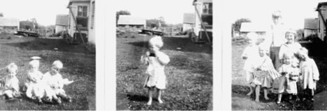
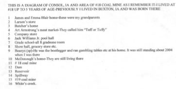
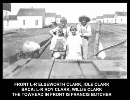
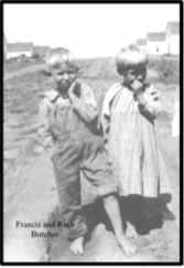
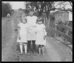
Having said this I will skip to the time we were living in a coal camp called #18 and it was from there that we moved to Bucknell in 1918. I can’t say too about Bucknell now as it was so closely related to #18. #18 was the only source of power for #19. #18, not only had steam power from a large boiler system but it used that power to produce large currents of electricity which transmitted to the #19 coal mine area. It was the only mine I knew of that had this facility. There was only one ridge of hills between #18 and #19 and less than two miles between them. Below are pictures when we were living in # 18 just to show what we looked like in about 1916. I am the tot in the middle picture.
BUCKNELL/HAYDOCK
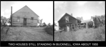
The very first thing I need to tell my readers is where this double named town was. I need to tell you its boundaries, its drainage system, its topography and my ten years of living there from 1918 to 1929. By the time our family left there in May of 1929, the coal mines, which was the only industry had been on strike by the miners for about two years and refused to return to work as the Consolidation Coal Company wanted to cut their wages. When we left the Coal Company had begun to sell the company houses for $50.00 each or 3 houses for $100.00. Some had already been moved or torn down when we left.
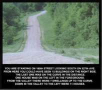
The location of this town was fully encompassed in Wayne Township of Monroe County, IA. When there is need to identify a street I will use the names that exist today. Streets were not named in my time there. The Eastern end of the town was 525th Street and the West end was 160th Street. 160th Street, where it rums north and south is also the western boundary of Wayne township. About half way between the East and West boundaries there was 527th Ave which ran north and south and made a “T” intersection with 160th Street.. The South boundary was Whites Creek, which flowed generally in a east/north direction to the eastern boundary and less than a quarter mile from South of 160th Street. The northern boundary was a small creek that started in the hills just West of the Western boundary and less than a half mile north of 160th Street where it flowed almost directly East then to the Northeast and finally to the Southeast where it converged with Whites Creek just East of 525th Street.
There were 8 drainage areas in the whole length of the town. I have numbered them 1 through 8 for convenience and for future locations I may use in this record. I call them drainage areas because there was no source of water to flow except the rain, snow and sleet. The first 6 flowed from North to South and the 7th one was near the West end of the town and flowed North into the Northern boundary drain. I have numbered them 1 through 8. All of these had their drainage across 160th Street. The first one was at the bottom of the first hill as you come from the east end of the town. The second was at the bottom of the next big hill. The 3rd was just west of 527th Ave. In fact it flowed through between our house and the one next door to us on the west. We lived on the north side of 160th Street at 527th Ave. The 4th was in the very next valley. The 5th creek was about a ¼ mile west from #4 and should be quite noticeable if you look closely as it was sort of deep on the south side of 160th Street. Matt Batista’s show hall was on the east side of it. #6 creek was at the bottom of the next big hill, the biggest one in the town. #7 was almost to the west end of the town, maybe 100 yards east of the boundary. I think there may be a pond near there now. It is the only drainage that flowed north. If you visited there now you would have to look very carefully to discover them. There was also another drainage that flowed from West to East and finally converged with Whites Creek at the east edge of town. I will call it # 8.The drainage valley began about one half mile east from the west boundary and maybe two hundred feet south from 160th Street and flowed all the way East through the town and converged with Whites Creek. The rest of the drainage to the South side of town was from the hills that sloped south to Whites Creek. Whites Creek always had some water in it. It began several miles west of Bucknell but I never knew its source of water. In fact a cousin and I skated a long way upstream and except for a few tributaries, I don’t remember any springs or any other source of water to empty into it.
THE DRAINAGE SYSTEM
The topography of the land was so hilly and the slopes so steep that selected places were chosen to build houses. In that day it was a necessity; nowadays houses are built anywhere. Houses were built up on flat plateaus, on ridges between valleys or in valleys where suitable. During this record, I will try to give you some idea of how places were chosen for houses. Eventually, there may have been 300 to 400 company houses built in the area and the population grew to about 5000 people. Company houses were all the same; 6 rooms that were 1 1/2 stories. There was a kitchen, dining room, one bedroom and a living room on the ground floor and two bedrooms on the second floor. There were a few farms scattered around the area and some company houses when we arrived, but really very few of them were left.
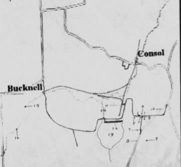
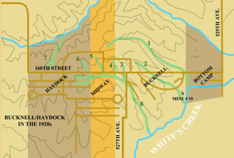
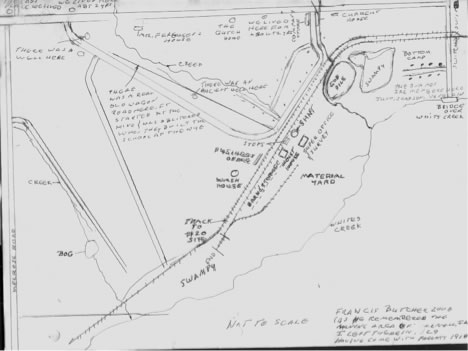
The approximate boundaries of the areas called Bucknell, Midway, Haydock and Bottom Camp are indicated in the above map with shading.
BUCKNELL
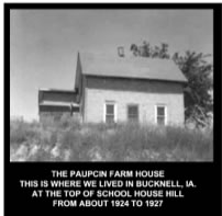
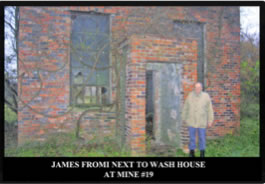
There was not much to the #19 coal mine area when we moved there in 1918, but the coal mine there had been operating about two years at the time. I was not quite 5 years old at the time. There were about 6 homes built at the East end of Bucknell, south of the railroad tracks, which entered Bucknell from the East. We called this “Bottom Camp” as it was the lowest place in altitude around the whole area. The mineshaft was located about a quarter of a mile southwest of these homes and about 1/8 mile south of 160th Street. Probably 5 homes were already built right across the tracks from the mine area to the west. There was a very steep hill (we called it Mine Hill) across the tracks from the mine starting just southwest of the mine and ascending up to the southwest and then curving to about 15 degrees north of west until it intersected the main road at a Y at the top of a hill we called #19 hill and later on when the schoolhouse was built we called it Schoolhouse Hill. At the top of Mine Hill, where it began to level off there was a narrow plateau about a third of a mile long. On this plateau there were about 22 houses built, 9 on north side of the road and 13 on the south side and beginning at the top of the hill and running west. Besides the Company Store, which was just a short distance north of the mine shaft, and on 160th street, the main road running East and West, there were two or three little stores and a barber shop on the North side of the road just East of Drainage #1. There was a street at the east side of the Company store that began at 160th street and went south to the coal mine area. There may have been a few other houses there when we moved there but I have no remembrance of any. There was no street, as such, between the houses on the hill. There still was an abundance of grass and the only thing you could say was a road were the ruts of the wagons that were used during the construction of the houses. As far as I know, there were no automobiles in the whole town. Construction was still being done on these houses. They were still building porches and steps where needed. We first lived with an Uncle of mine named Alex CLARK. They had their children’s sleds piled up in a manner to make steps into the kitchen area. When we moved there, no schoolhouse had been built as yet. We were told that they had school in the upper story of the Company Store until it burned down sometime before we moved there. It was rebuilt but the school had been moved to a Company House just South of the store. I think I attended school there for a year until the grade school was built and encompassed within the Y, which was spoken of before. Later on, this house became the home of Dr. COOK, about 1920, an Army medical Dr who still wore his broad brimmed army hat and at times some of his army clothes. I got my first small pox vaccination there. He served the community until about 1926 or 1927 and then moved his family to California. Before Dr. Cook’s arrival, the closest Dr. we went to was Dr. MORAN, but he lived eight miles south of us at a little town named Melrose, a stop on the C, B, & Q for the area. At this early date, he did not have a car and his house calls were made by horse and buggy. When you consider that all the roads were just clay dirt, you can imagine the task it was for him in inclement weather of rain, snow, sleet and all the other things that affect roadways. Later on, Dr. MORAN bought a Model A Ford roadster. Later on another doctor moved to the area of Haydock whose surname was Chester.. Below are maps and some pictures from the early days of Bucknell/Haydock, IA and current pictures.
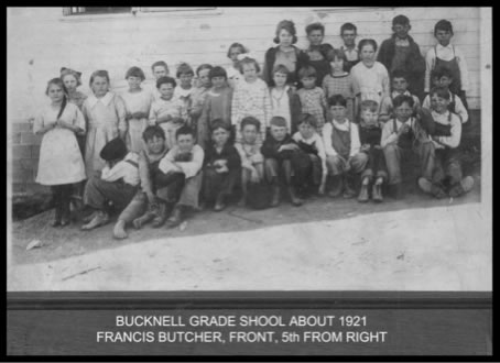
SCHOOLS
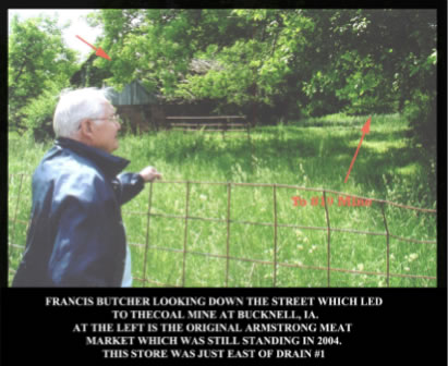
As I have said, the first school was held in the second story of the company store until it burned down before we moved there. The school was then held in the first company house south of the Company store which had been rebuilt. The store was just west of creek #1.There was a road going south to the mine immediately east of the store and on the east side of the street was Armstrong’s meat market
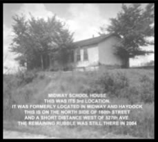
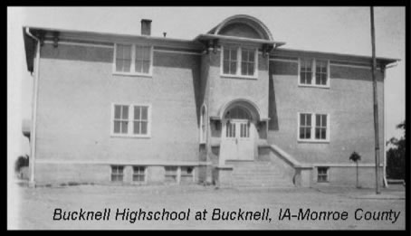
The next school was opened about 1919 at the top of #19 hill west of Drainage #2. About 1925 a school was built in what we called Midway which was 300 feet or so west of Drainage #5. This school was built, because of an overflow of pupils at the first grade school. A few years later when it was no longer needed it was moved to the high school grounds about two to three blocks south of 160th Street and near the Drainage # 8 that ran all the way through town and near its head at the west end.
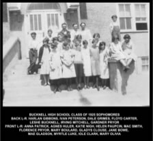
When I lived in the section called Haydock which comprised about a third of the town at the west end. I went to school in a company house for two years until the high school was completed in about 1922.. This was near the high school. We moved back to the east section of town about 1924 or 1925 and I attended the school there. For some reason or another we had to go to school at the high school for our 7th and 8th grade classes and I graduated from elementary school in 1926. I completed high school second year there in 1929 and we moved to Illinois in May of 1929.
BUSINES HOUSES
The business houses were scattered all over the town. I have already spoken of those near to Drainage #1. About half way between the east end of town and Drainage # 1 on the north side of 160th Street was the Bucknell Post Office. Next west was Manny Lobbins home and garage. Next west about 100 feet or so was Jack William’s pool hall and about another 100 feet was the show hall which later was a soda pop factory run by Carl Garrett and Art Bloomgreen a brother-in-law to Carl. Just across Drainage#1 west on the north side was a pool hall that was operated originally by my great uncle, George Chambers. I think it was a man called Dusty Rhodes who took it over afterwards.
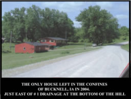
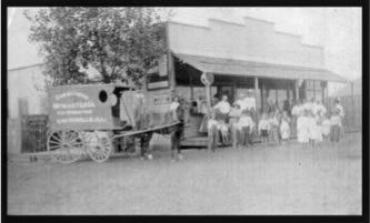
On the south side of 160th street and immediately to the west side of drainage #1 was Armstrong’s meat market. This building was still standing in 2004. West across the street was the Company Store. A picture of a typical mine town company store is shown. This store was in Sawyerville, Illinois … one of the mine towns where the residents of the Bucknell area migrated when the mines closed.
John Baxter was the owner and operator of the company store and grocery stores from as far back that I know of in the 1870s at Muchakinock, IA when it was at its height in coal mining.
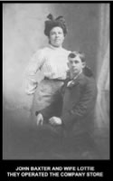
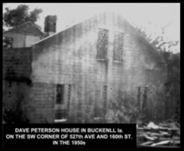
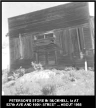
On the south west corner of 527th Ave and 160th Street was Dave Peterson’s grocery store and south beside it was their house.
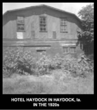
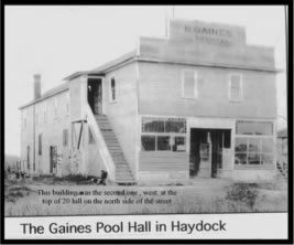
On the bottom of the hill south from Peterson’s store was Lambini’s ice cream parlor and grocery store. On the south side of 160th street a little further west of Peterson’s store was Pete Bunocore’s (sp) meat market. On the same side of the street on the east side of drainage #4 was Hartman’s Tailor Shop. Another hundred yards further on west was Prentice’s ice cream parlor, then going further west a short distance was Olivia’s pool hall and residence and next west the show hall on the east side of Drainage # 5. Across the creek west was Matt Batista’s bakery and confectionery and Pignari’s hardware store. The next business establishments west were at the top of the hill from Drainage #6 and this hill we called #20 hill. At the very top of this hill and on the north side of 160th Street, the Haydock Hotel was built. It was operated by a Wilson family and their son Robert was in the same grade in school as me. It was used as a barn at some time after Bucknell was abandoned by George Grimes whom I also knew from high school. Next west of the hotel was the R. Gaines pool hall stood.
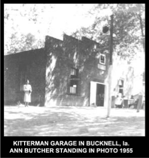
The next business to the west less than a quarter mile was Kitterman’s garage. It was a two story building with residence in the top story for Kit and Emma Kitterman and a very young daughter, whose name was Catherine. He sold Chevrolet's and my father bought a new 1928 model. He later moved to Albia where his wife had a restaurant and Kit had a garage.
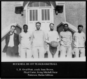
The next place west was Langlois Hall. Two sisters ran this by surname of Langlois. It was a rather large building too. They had a snack counter and a few tables in the front part of the building. They had a little grocery business also. To the rear was a fairly large dance hall. The high school basketball team practiced there also but could not have games as the ceiling was not high enough so all their games were played away from home. Upstairs they had rooms for rent and they were nearly always full. One of the sisters always wore men’s clothes and was rather a rough and tough individual. Everyone called her Ben. .Her sister was a refined lady and was a very fine musician. They were French . The next place west was my father’s pool room and was on the north east corner of the only main road there that went north and south. Later on he sold it to some people by the name of Zupon and they had a store there. They built a home just east of the store. Across the street., `south on 160th Street there was a lumber yard in the early days of Haydock but it was later moved west on the north side of 160th Street Across the street, west, from the pool hall was John Thomas’s drug store. It was two stories high and John and his brother lived in the upper story. Next to the drugstore to the west there was an open space maybe more than 200 feet. This was used for a recreational area, itinerate preachers of all faiths pitched their church tents there when in town, carnivals moved in and various public meetings occurred there. Adjacent west of this space was Silk’s board and rooming house. Silks had their residence there. They also had a little store and had the Haydock post office; Mr. Silk being the postmaster. Right next to it west was the White Methodist church. Next was a long space with no buildings; only a scraggly bunch of short bushes and trees along the north side the road for maybe 300 feet. The next business to the west was a lumber yard. The next business to the west was J. E. Larson’s large grocery store. It was on the north east corner of where 160th street makes a 90 degree turn to the north and faced the east/west portion of 160th Street. 160th Street going north was also the western boundary of Wayne Township. The only other business I recall in that area was south from 160th Street on the main street I mentioned before, about two blocks. It was just across the street from the High School to the west. This was a later meat market and grocery store of Art Armstrong after he had abandoned his meat market on the east end of town. The East end building was occupied later by the Pentecostal Church people and was about the last original building that was still standing in 2004.
CHURCHS
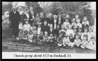
The Church Group I have shown below held services at the Community Church building. It was built by the Consolidated Coal Co. on the North side of 160th Street in Midway and anyone could hold their church services there. There was a church board made up of three members and they delegated groups who wanted to worship there besides the times which were available. The Pentecostal church held their services there in the evening. I don’t know for how long after we moved away in 1929. The Reorganized Church of Jesus Christ of Latter Day Saints (Now named Community of Christ) held their services there in the morning for many years.
THE COAL MINES
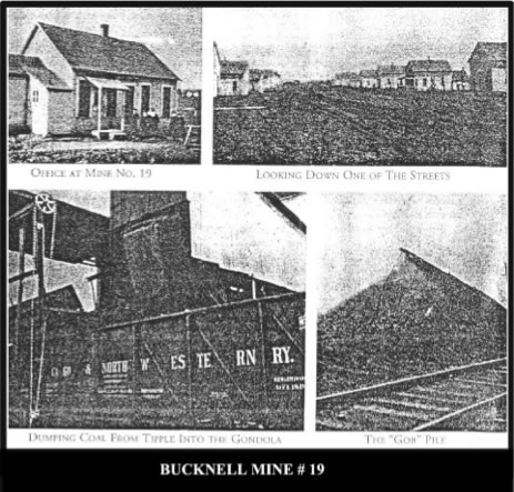
Have you ever been very close to a mine shaft. Air is blown down an airshaft to the coal vein far underground. It is circulated under ground so that it is available in every working place. When it goes through all the mine there is only one place for it to go and it exits up the main shaft. If you are near you get a feeling that this air is different. Of course with all that air pumped down it comes out a little forcefully and you are fully aware of it. Then too, it picks up many smells from its journey. It picks up a little acrid smell from the chemicals that are present underground, especially sulfur and there is an airy moisture feeling to it. It picks up human and mule excretions, smells of all the mules used in # 19 mine and the sweat of both men and mules that worked below. At the Bucknell mine the hoisting of cars from the bottom of the shaft was done by electric motors and there was only a hum from them, but the noise otherwise was almost deafening. The coal was hoisted up in what was called the tipple, a structure which was built over the mine shaft; the one at Bucknell about 60 feet high. The pit cars were tipped at the top of the tipple and then by gravity rolled down through the conveyors, crushers, where it was broken into smaller pieces, the screens where it was separated into different sizes and finally loaded into large commercial coal carriers for transport to where ever needed. At night all the rock, loose slate and other dirt were hoisted but conveyed in a different conveyor to a large storage bin. At a proper time it was dumped into special pit cars and carried to the top of the “dirt dump or slate pile.” This special pit car had swinging sides on it which could be locked shut and there was a device at the top of the dirt dump which unlocked the sides and let the debris fall out of the pit car which rolled down the sides of the dirt dump.
There were two sets of tracks at the mine. One track went under the coal chute. The other set ran nearly parallel with the other and continued southwest about a mile to where the Coal Company was planning another mine to be called #20. Empty coal cars were pushed past the mine on the tracks under the coal chute up an incline awaiting their turn to be let down under the coal chute to be loaded. This operation needed the help of at least three men. One man saw to it that only one coal car was let down under the coal chute at a time and came under control of a man called a “trimmer”. He had control of the coal car and was responsible for loading the car properly by letting it move down the track. He would unleash it after it was filled and it would roll down the track over the weigh scales where the weigh man would weigh it and let it roll along. The first man by that time was waiting for it and climbed aboard and let it roll down the track to the storage area to the proper place and brake it to a stop. This storage area could hold about 20 cars of coal. When the second car was let down he would let it gently engage the automatic coupling on the first one and so the cars were locked together. He then coupled the air hoses which were just under the coupling device. There also was a grease “monkey” who saw that the cars were fit to be loaded and that he grease wells on all the wheels had plenty of grease. I don’t recall any large steel gondola coal cars in my days there. They were steel but they were much shallower than the huge gondolas of today. Of course there was a large material yard between the mine and Whites creek . There were the props. These held up the top for the miners below. In this mine there was always the danger of loose shale or rock on top of the coal and props helped hold it in place. Props were cut of Tamarack or oak timbers eight feet long and had to be at least four inches in diameter on the small end.. There were caps and wedges in bins. Caps were of oak and they were eight inches long, six inches wide and two inches thick. These were used when the props were short and on top of the props or caps the wedges were driven in to tighten up the props to the ceiling. There were bars. These were of oak timbers and were about eight inches in diameter and twelve feet long. These were used to span a long open space of the top and were held against the top by props. These were used at switches on the pit car rails which created longer spaces at their locations. There were steel rails that were sent below when more track had be laid. There was a shed for all the electrical supplies that were needed both at ground level and down in the mine. There were the mule barns and storage houses for their food. And fresh water had to be sent below for the mules.
Down below there was a section set aside for the mules to rest and sleep and a man was used to see about their needs. Every so often the mules were brought up to ground level for a little relaxation and open land exercise. This was a gala occasion and people would watch for their favorite mule. One of the favored ones was named Washington. He was pure white and stood out from the rest.
A nice brick building was built about 20 or 30 feet east of the mine shaft that contained the mine managers office and the civil engineers room. The mine manager was Ed Bucknell and the town was named for him. I heard that he later went to Pershing, IA and the coal mine there. Later on I know he lived in Des Moines, IA and still busy at coal mines.
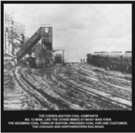
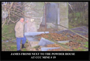
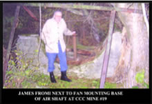
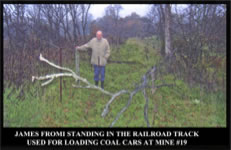
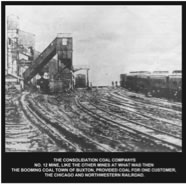
Below are some pictures that show a friend of mine at some of the various place that were at the mine. His grandfather lived just east of Drainage # 1 on 160th Street. His father was designated as a hoisting engineer for mine # 20 about a mile west of # 19 but it was never sunk. There is also a picture of mine #12 at Buxton.
AND NOW THE SAD PART
The Consolidation Coal Company had sold the whole operation to the Superior Coal Company of Gillespie, IL about1926 or 1927. Superior at first thought the mines would be operating again after a strike was settled but they were so wrong. The miners never agreed to go back to work so in 1928 or 1929 the company decided to completely abandon its efforts there. In the meantime my father and a man Bill Pierce were kept in the area to see about the necessary needs of quitting the area. They loaded out all the materials in old wooden coal cars to be sent to the mines around Gillespie, IL. They shipped everything that was possible to ship that remained at ground level.. Of course, water had to be pumped out of the mine and since there was no longer any electric power something had to be done. My father and Bill Pierce both had old White Co. automobiles. They took the engines out if the cars , took them to the mineshaft area and fastened them down tightly to a stable platform they built. They fitted a belt drum, somehow to the end of the transmissions and belt them to dynamos that provided power to the pumps down the mine shaft. These engines did their duty in an alternate fashion until the Superior Coal Company felt , “We will close up for good”. Then there came a time when the coal company decided to abandon everything. During those two or three years there was a difficult time for people. Imagine about 5000 people out of work and no other industry where they could apply for work in the area. The closed larger towns were about 16 miles away. Few people had cars to leave the place. I saw people walking out of town wit what they carry on their backs. I saw trucks loaded to overfill by people who could afford a truck. Wit no car of their own they clambered atop their furniture in the truck and so got transportation to where they were going. Due to the kind hearts of Iowa people after hey heard of Bucknell’s plight , huge boxes of used clothing was shipped to the area and distributed at the high school. During the fall and winter those who were hunters gathered together to kill every kind of game there was of animal or bird to feed the hungry. I have seen the whole back seat area of a model “T” Ford filled with game. This was distributed to the needy. About this time the State Highway 34 was being paved and some people got jobs there and maybe some stayed on across the state to Kansas. My father also had a feeling that he would have no job either at some time so he entered into a partnership with my uncle Alex Clark and Theodore Boulard into a coal mining operation at Farmington, IA, called the Blue Jacket Coal Co.. My father was still busy at Bucknell, IA for the coal co but in the summer of 1928 or it may have been 1927 I went to Farmington, IA to help them sink the first shaft. We slept under the stars in good weather but during inclement weather we all crowed into a large cook tent. Sanitary needs were taken care of over in the woods near us and bathing was done in a rock bottom creek which was just a few yards from us. Through long, long, times the rock had eroded out and had formed little bathtub like holes. The water in these was heated by the sun in the daytime and was warm enough to bathe. My father also bought a Mode “T” Ford. He had a carpenter strip everything away back of the front seat to the frame. He built a double walled large box on the back with a door on the rear end. These double walls were filled with sawdust and made a fine refrigerator when ice was placed in it. My father was very friendly with the butcher across the street named Pete Buonocore (sp). Pete had agreed to furnish fresh meat. I was to be the driver and we were going to deliver fresh meat for sale over the country side. Also, my father was raised on a farm in West Virginia and I think he would have gotten into that business also if need be.
But those things never came about. My father and Bill Pierce got news in about March or April that they were being transferred to the mining operations at Gillespie, IL and in May sometime we shipped our furniture by rail to Illinois. We, my father and mother, my sister and I and a cousin piled into a 1928 four door sedan Chevrolet along with two good sized dogs and headed for Gillespie, IL.
Francis Butcher