http://www.buxtoniowa.com • Consol, Haydock & Buxton Iowa, USA • 1871 - 2014
Where Was Haydock?
As a tour guide on one of the two buses to the coal mine camps of Bucknell and Haydock during Monroe County’s 150 year celebration in 2009, it was interesting that the other guide and I didn’t agree on the boundary location of Haydock and Bucknell. Neither coal mining camp was an incorporated town, which accounts for the disagreement as to the boundaries of the two camps. If one wishes to really “stir the pot” farther one only has to add the question of Midway’s location to the foray.
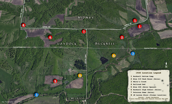
For the sake of sanity, Midway will not be included in this discussion on Bucknell and Haydock. As the name would suggest, Midway was midway between two locations – Bucknell and Haydock. The Melrose Road (527th Avenue) that ran south from H32 (160th Street) was considered pretty much the east and west dividing line between Bucknell and Haydock. Melrose is located five miles straight south of Bucknell and Haydock – just off US Highway 34 between Chariton and Albia. Which camp was east and which one was west of the Melrose Road (527th Ave) is what conjures up the debate.
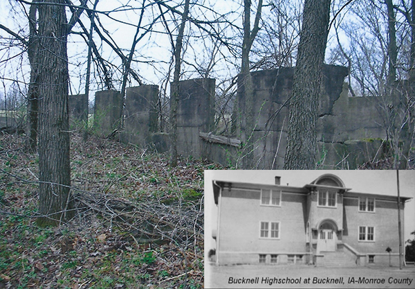
Those who suggest Bucknell was west of the Melrose Road simply note that the Bucknell high school and grade school were to the west and located close to what was known as Mine 20 hill (although Mine 20 was never opened and was west of the Melrose Road and south near White’s Creek).
To further validate the contention that Bucknell was to the west is the November 29, 1921 article in the Albia Union that “Bucknell: The New Industrial City” was to be for the most part in section four of Wayne Township – near where the Bucknell high school was built and the location where the grade school was moved. Section 4 is west of the Melrose Road. The best argument for Bucknell being west is the plat survey of Section 4 in Wayne Township for the town of Bucknell by RW Butcher on June 6, 1921. Actually, the name of the town on the plat was Almack not Bucknell and the date was prior to the announcement by the Consolidation Coal Company on November 29, 1921 that “The New Industrial City” of Bucknell would be located in section 4 of Wayne Township.
Based on these “rock solid” arguments, Bucknell was west of the Melrose Road. That said, where was Haydock? It certainly wasn’t located east of the Melrose Road since that was the area around Mine 19 and commonly called Bucknell’s bottom camp. I do not know the exact date when the name Bucknell was first used or the date it originated. However, the name Haydock originated after John Day was named the superintendent of the Consolidation Coal Company in 1922. John Day was from a town in England called Haydock. The Haydock town name was never suggested until Day became superintendent. My family photo album includes a photo of Haydock, England that was taken when my parents, Ray and Iva Peterson of Charles City, visited the town.
In my interviews with Francis Butcher, who lived in 13 locations in the eleven years (1918 – 1929) he lived in the area, he stated Day was proposing a rather elaborate Consolidation Coal Company (later sold to the Superior Coal Company) mining headquarters near Mine 20 that was located in Section 9 of Wayne Township (still west of the Melrose Road). I am fairly certain Day was the originator of the name Haydock and the name was for the area west of the Melrose Road. As we move the time capsule forward and once the name Haydock gained prominence, the area west of the Melrose Road, other than Bucknell High School, was considered Haydock except for the area called Midway. For those who lived and worked in the area, including my father Ray Peterson who delivered groceries for the Peterson stores throughout the area and Francis Butcher whose father did all of the surveying for the Consolidation Coal Company, Haydock was the area west of the Melrose Road and Bucknell was relegated to its original area east of the Melrose Road.
I have observed that most current maps and even older maps of the area both east and west of the Melrose Road make little mention of Haydock, but rather the name Bucknell is used. Yet most of us with our roots in the area refer to the whole area as Haydock with little mention of the name Bucknell. Dorothy Schwieder, a professor at Iowa State and the author of a number of books on coal mining camps, became so frustrated trying to disseminate between Haydock and Bucknell that she simply called the area Haydock since all those she interviewed for her books called the area Haydock with little mention of Bucknell. Her books reflect that very fact. The error in her approach is her reference to Haydock in dates before Haydock existed. Now that we have essentially settled the argument between “Where were Bucknell and Haydock?” we can start an argument about “Where was Midway?” – only on another day.
To a certain extent, those who maintain Bucknell was located west of the Melrose Road are correct – unless of course they are referring to a time after 1922 when the area west of the Melrose Road became Haydock and the area east of the road remained Bucknell. That my friend is a diplomatic manner of resolving the debate once and for all – hopefully!
Now for those who choose not to argue the merits of each of the contentions as to the locations of Haydock and Bucknell, it can be noted on the maps of Haydock / Bucknell in the 1920s by Francis Butcher the locations of the Post Offices for Haydock and Bucknell are number 20 and number 1, respectively. Simple enough if it was not for the fact that a Google search on the Internet shows the Haydock Post Office in Francis Butcher’s Bucknell Post Office location (#1). Wikipedia has a credibility issue with information on Monroe County coal mining history. As an example, coal mine 18 is identified as a Buxton mine when in fact mine 18 was nearly 20 miles from Buxton. Mine 18 was between the coal camps of Consol and Bucknell’s bottom camp, not Buxton.
In the end, I am not sure who really cares about all of the details of where Bucknell and Haydock were located, unless of course your roots are in the Monroe County coal mines and camps as is true for me and the rest of the Peterson/Nylander family.
Gordon R. Peterson
Peterson, who was born and went to school in Charles City, now lives in Minneapolis, MN. His grandparents owned convenience stores / gas stations / grocery stores in Coopertown (Buxton), Consol, Haydock, Georgetown and at the Melrose corners. They remained in Haydock after the mines closed in 1927 until World War II. After the end of WWII they farmed the land once known as Buxton’s East Swede Town.
November 2011


